Carleton Place
West
Fast Facts
- Population: 12,517 (Statistics Canada, 2021 Census of Population)
- Size: 10.33 km² (Computed from the Statistics Canada Census Subdivision boundary polygon)
- Distance from Parliament Hill: About 47.0 km west (straight-line distance)
Overview
Carleton Place is a separate town on the Mississippi River, about 47 km west of Ottawa in Lanark County. It is not part of the City of Ottawa. Settled in 1819 and incorporated as a town in 1890, it grew as a 19th-century mill town, and its walkable historic downtown along Bridge Street — including the Richardson Romanesque Carleton Place Town Hall — remains a defining feature of the community today.
Boundaries
Carleton Place is a separate incorporated town with its own official municipal boundary, sourced from Statistics Canada's Census Subdivision boundary file rather than the City of Ottawa's Neighbourhood Study, since it lies entirely outside Ottawa.
Map
History
The area now occupied by Carleton Place was inhabited by the Algonquin before European settlement. The town itself was settled in 1819 on the Mississippi River, a tributary of the Ottawa River, and was incorporated as a village in 1870 and as a town in 1890.
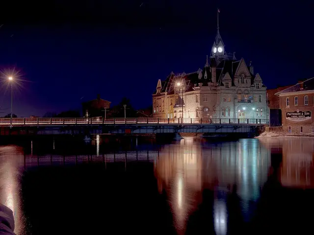
Carleton Place's location on the Mississippi River made it a 19th-century mill town, and the town's Richardson Romanesque Town Hall, built in the late 1800s on the riverbank, remains a defining downtown landmark.
The town's historic downtown along Bridge Street, developed during this mill-town era, has retained a walkable character with heritage commercial buildings, some later repurposed — a former 1873 log grocery store and confectionary building, for instance, was moved to now house the town's Tourism Information offices in 2007.
Carleton Place has grown rapidly in recent years, with its population increasing by nearly 18% between the 2016 and 2021 censuses, making it one of the fastest-growing municipalities in the region.
Claim to Fame
Carleton Place's defining feature is its walkable historic downtown along Bridge Street on the Mississippi River, anchored by the Richardson Romanesque Town Hall, a legacy of its founding as a 19th-century mill town.
Surrounding Neighbourhoods
Carleton Place is a separate town bordering Ottawa's rural west end (West Carleton) to the east and the Town of Mississippi Mills (Almonte) to the north.
Architecture
Downtown Carleton Place along Bridge Street retains 19th-century commercial and civic buildings from its mill-town era, including the Richardson Romanesque Town Hall, alongside newer residential subdivisions built during the town's recent rapid growth.
Restaurants
- Sagar Indian Cuisine — Indian
North Indian restaurant at 156 Bridge Street, serving Carleton Place since 2017.
Visit website
Grocery Stores
- The Granary Bulk & Natural Foods — Natural foods grocery store
Bulk and natural foods grocery store at 107 Bridge Street, in the heritage 1898 Keyes Block building.
Visit website
Pedestrian and Cycling
Downtown Carleton Place along Bridge Street is walkable, with pathways along the Mississippi River offering additional walking routes.
Schools
- Carleton Place High School — Upper Canada District School Board
Secondary school (grades 7-12) at 215 Lake Avenue West, established in 1922.
Visit website
Transit Options
Carleton Place is not part of OC Transpo's service area; residents travel primarily by personal vehicle along Highway 7 to reach Ottawa.
Nearby on This Site
No listings yet in this area.
Official Information
Last verified: August 27, 2026